


Overview
- The SMN placed parts of Buenos Aires, Santa Fe, Entre Ríos, Córdoba and other provinces under yellow alerts for storms and winds on Monday, with some northern highlands warned for gusts up to 140 km/h.
- Forecasters expect the low to deepen overnight and peak Tuesday, bringing roughly 50–100 mm from Tuesday into early Wednesday across the AMBA, north of Buenos Aires, southern Entre Ríos and portions of Santa Fe, though models differ on where maxima fall.
- In the Buenos Aires metro, guidance calls for persistent rain Tuesday, easterly winds turning south by Wednesday, 45–60 km/h gusts, and a rapid improvement later Wednesday.
- Mexico’s SMN and Conagua maintained outlooks for very heavy to intense rainfall, highlighting 75–150 mm in southern Chiapas and strong storms in the Valley of Mexico, with CDMX officials flagging a 18:00–23:00 window for the heaviest cells.
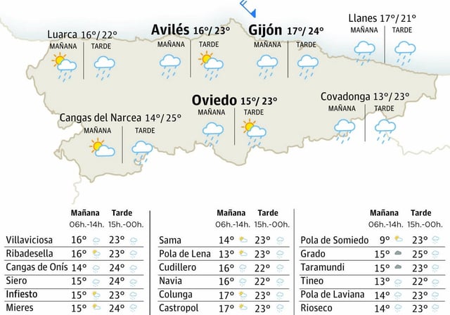
- Northern Baja California faces maximum temperatures above 45 °C on Monday, while Spain’s AEMET expects a shift to cooler, showery weather in Asturias after days of extreme heat and fires.