Overview
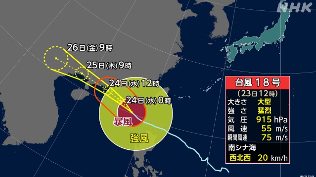
- Japan’s Meteorological Agency reports the large, violent system moving west-northwest in the South China Sea, with central pressure at 915 hPa and peak winds of 55 m/s as of Sept. 23 morning.
- Okinawa forecasters project significant wave heights with swells on Sept. 23 of 4 meters around the main island, 5 meters near Miyako, and 6 meters around Yaeyama.
- Officials urge caution in the Sakishima islands for lightning and violent gusts, including tornado-like winds, with cloudy, rainy conditions and strong southeast to east winds expected.
- Under a high-pressure ridge, Okinawa Main and the Daito islands stay mostly sunny with a chance of sudden showers despite elevated coastal hazards.
- Ferry disruption continues after 60 cancellations on Sept. 22, with one Yonaguni–Ishigaki service already canceled for Sept. 23 and other operations under early-morning review.