Overview
- Unseasonably warm, dry weather persists through the weekend across large parts of the U.S., with highs in the 80s and near-record readings possible in the Upper Midwest and Northeast.
- A developing low near the Bahamas is lifting north, driving nor’easter-style onshore flow, with Coastal Flood Watches along parts of Florida and Georgia and beach gusts up to 30–40 mph.
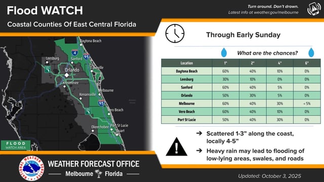
- South Florida’s Treasure Coast is under a Flood Watch through Saturday night, with 4–6 inches possible in spots after some areas already picked up 1–3 inches and isolated 5 inches.
- Central and Northeast Florida face widespread showers with coastal flood alerts, including flood watches for Volusia and Brevard, a coastal flood advisory for coastal Volusia, and a warning for Flagler, plus high surf and dangerous rip currents.
- Southeast Georgia and the Lowcountry could see 1–2+ inches and localized street flooding Sunday–Monday, with elevated tides increasing minor flooding risk as drought conditions lend urgency to the incoming rain.