Particle.news

Download on the App Store

South Texas Braces for Life-Threatening Flooding as Storms Intensify

Heavy rainfall and severe thunderstorms Thursday into Friday are expected to bring flash flooding and isolated extreme weather to areas south of Houston and along the Gulf Coast.

The regional National Weather Service office for Houston and Galveston is placing several coastal counties south of Houston under a flood watch this week.
These two models show two very different weather scenarios Thursday morning across Texas. The High-Resolution Rapid Refresh model, left, depicts heavy rainfall across the lower and middle Texas Gulf Coast. The North American Mesoscale model, right, suggests heavier downpours will be west of Houston.
Heavy rain with totals in the double digits will ramp up flood risks in Texas.
This map shows rainfall estimates between Wednesday morning and Thursday morning, according to the National Oceanic and Atmospheric Administration. The highest rainfall totals through Thursday morning have been between Corpus Christi and San Antonio, where 4 to 6 inches have fallen.

Overview

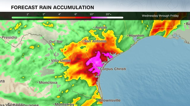
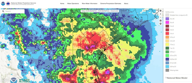
  • Rainfall totals south of Houston, including Corpus Christi and Matagorda, could exceed a foot, with flash flooding risks heightened in these areas.
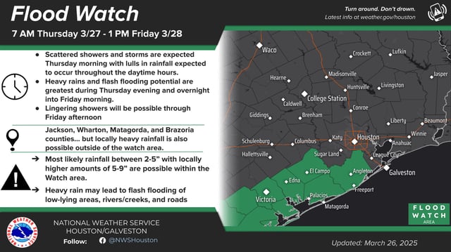
  • Flood watches are in effect for several Southeast Texas counties, including Brazoria, Matagorda, and Jackson, through Friday afternoon.
  • Houston is forecasted to receive 2 to 4 inches of rain, while San Antonio may see 1.5 to 3 inches, with localized higher amounts possible.
  • Severe thunderstorms with large hail and damaging winds are possible in South Texas, particularly south of San Antonio, adding to safety concerns.
  • The storm system, fueled by Gulf moisture and a low-pressure area from northern Mexico, is expected to weaken and move eastward by late Friday, with conditions improving into the weekend.