
Overview
- Morning commutes across the eastern U.S. and Gulf Coast turned wet, with embedded downpours and isolated thunderstorms producing ponding on roads.
- The Storm Prediction Center placed parts of the Mid-Atlantic, including the D.C. area, under a marginal risk for damaging wind gusts, localized flash flooding and an isolated tornado.
- Training thunderstorms in sections of Louisiana have prompted flash‑flood concerns, bringing helpful but uneven drought relief in narrow swaths.
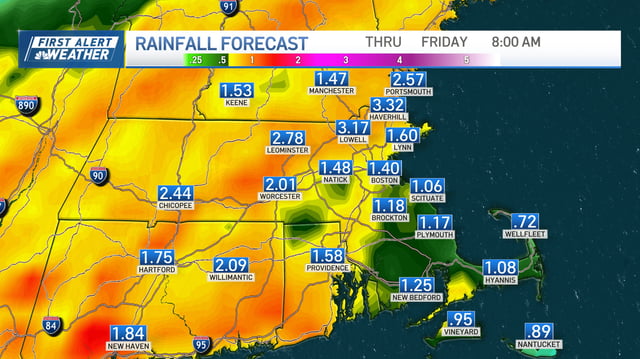
- A second round of showers and storms is expected this afternoon and evening with the cold front, with the heaviest bands capable of 1–3 inches and localized street flooding.
- The front is forecast to clear the region by Friday, ushering in drier, less humid weather into the weekend as forecasters track Tropical Storm Humberto and a nearby disturbance with uncertain early‑week coastal effects.