

Overview
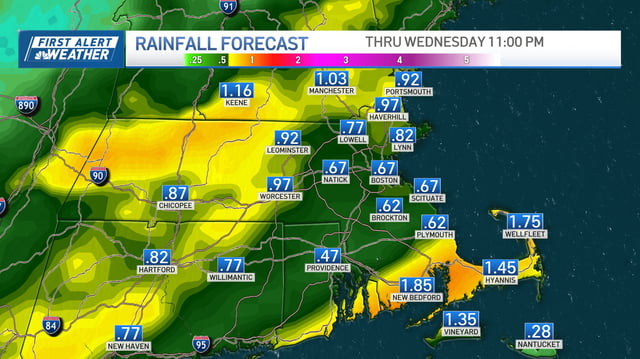
- Widespread showers and a few downpours arrive after midnight and taper by late Wednesday morning, bringing roughly 0.5–1.0 inches of rain for many areas with isolated higher pockets.
- Morning commutes could be slow with wet roads and brief heavier bands, with forecasters cautioning about slick first-raindrop conditions after the recent dry stretch.
- Temperatures drop 20 degrees or more behind the front, falling from 70s–80s to 50s–60s through midweek with breezy, drier air and clearing by Wednesday afternoon.
- Early-season frost risk increases inland late week, including a confirmed frost advisory in parts of south-central Wisconsin and potential frost Friday morning in cooler spots of the Northeast.
- King tides linked to the Harvest Moon raise coastal water levels midweek, and a tropical disturbance in the Atlantic has high odds of developing, though any U.S. impact remains uncertain.