


Overview
- SMN/Conagua projects heavy to very heavy rain, thunderstorms and possible hail on August 20 across multiple Mexican states, with intensities up to 75–150 mm in parts of Tamaulipas, Nayarit, Jalisco and Chiapas.
- Forecasts also flag sharp temperature contrasts in Mexico, with highs potentially above 45 °C in northeast Baja California and parts of Sonora and early‑morning lows near 0–5 °C in high elevations of Durango, Hidalgo, Estado de México, Tlaxcala and Puebla.
- Recent local impacts include about 30 mm of rain and urban flooding reported in northern Hermosillo, underscoring flood and drainage risks where storms train over cities.
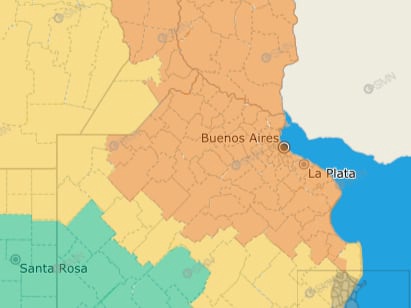
- In Argentina, the rain phase of the cyclogenesis gives way to a wind‑dominant period, with SMN yellow alerts for southwest to west winds of 30–50 km/h and gusts near 65–80 km/h across Buenos Aires (including AMBA), Santa Fe, Córdoba, La Pampa and Entre Ríos.
- AEMET and Meteocat say Spain’s prolonged heat wave is ending, with a notable temperature drop and renewed showers and storms—locally intense with hail and strong gusts—especially in Catalunya, Aragón, Comunidad Valenciana and Murcia.