Particle.news

Download on the App Store

Maxar Unveils Raptor Software to Overcome GPS Jamming in Drone Operations

The new system uses 3D terrain data and visual recognition to enable drones to navigate in GPS-denied environments, addressing critical challenges in modern electronic warfare.

Maxar Intelligence developed software that enables an autonomous system to navigate with precision even without GPS. The green line represents the drone’s true location in the real world on a specific flight path. The red line shows the location information sent by the drone without GPS. The yellow line shows the location information sent by the drone when using the software without GPS.
Image
Image
A Ukrainian drone unit carries out a reconnaissance mission at night hidden in a forest 5km from the front line and launches their drones at Russian positions where fighting continues in defense of the town of Pokrovsk in the Donbas region of eastern Ukraine on March 21, 2025.

Overview

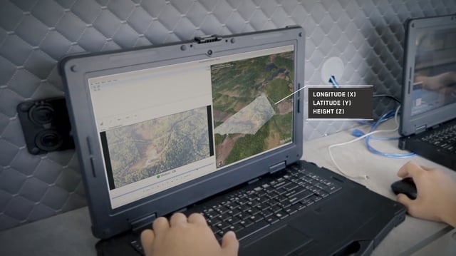
  • Maxar Intelligence announced Raptor, a software enabling drones to operate without GPS by combining real-time camera feeds with 3D terrain data.
  • The system has been tested in multiple countries, including an active conflict zone, and is compatible with both commercial and military-grade drones.
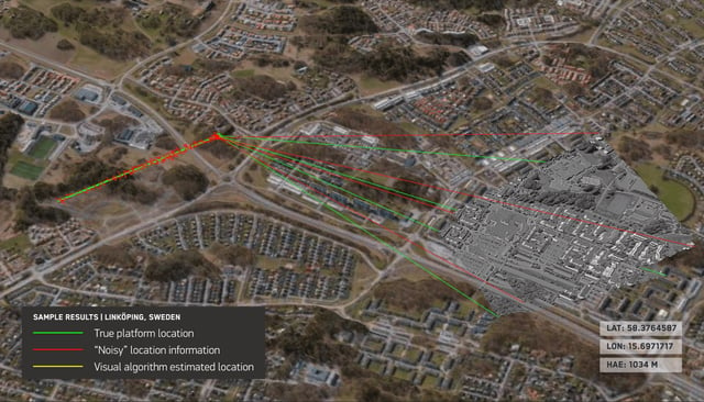
  • Raptor ensures precise navigation with accuracy within three meters, meeting NATO's highest standards for target location data.
  • The software allows drones to operate in low-visibility conditions, such as nighttime or low altitudes, and can function independently of live video feeds by storing map data locally.
  • This innovation addresses the growing threat of GPS jamming, which has been prominent in conflicts like the Ukraine war, and is expected to transform both military and commercial drone applications.