Overview
- The peer-reviewed paper, led by researchers at the University of Utah with UC Berkeley and the U.S. Forest Service, was published Wednesday in Global Change Biology.
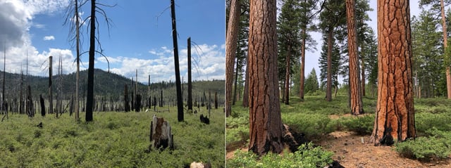
- Using 2018 airborne LiDAR collected by the Forest Service, USGS and NASA, the team mapped forest structure before five fires burned about 1.1 million acres in and around Plumas National Forest.
- Private industrial ownership was associated with 1.45 times higher odds of high-severity burning than public land and more than double the odds relative to non‑industrial private parcels.
- During extreme weather, stem density emerged as the strongest predictor of severe fire, indicating that targeted management can lessen intensity even as climate risks grow.
- The authors highlight selective thinning, shaded fuel breaks and prescribed fire as mitigation tools, while timber industry representatives caution against broad conclusions.