

Overview
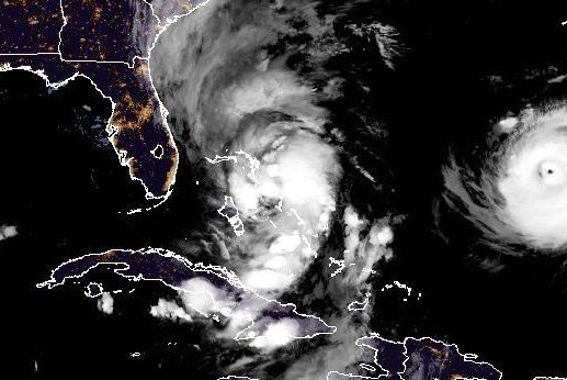
- Tropical Storm Imelda reached 40 mph Sunday night, located about 125 miles northwest of the Central Bahamas and 320 miles southeast of Cape Canaveral while moving north at 9 mph, according to the National Hurricane Center.
- Forecasters expect Imelda to strengthen into a hurricane by late Monday or Tuesday, cross the central and northwestern Bahamas, then turn east-northeast away from the southeastern United States by midweek.
- Tropical storm warnings are in effect for parts of the Bahamas, and earlier U.S. advisories placed tropical-storm watches along stretches of Florida’s east coast and nearby Georgia–Florida coastal areas.
- Coastal southern North Carolina could receive 2 to 4 inches of rain with a local maximum near 6 inches through Tuesday, as swells from Imelda and Humberto generate life-threatening surf and rip currents along the Southeast.
- Humberto has 160 mph winds and is expected to remain a powerful major hurricane offshore, sending large waves toward the U.S. East Coast beginning Monday.