Particle.news

Download on the App Store

Heat Dome Builds Over Midwest and East; Flood Watches Ease

Authorities warn of heat index values surpassing 110°F when the heat dome peaks this Wednesday.

UNITED STATES – JULY 10: Chair Susan Collins, R-Maine, right, and Vice Chair Patty Murray, D-Wash., prepare for the Senate Appropriations Committee markup of the “Commerce, Justice, Science, and Related Agencies Appropriations Act, 2026,” and other bills in Dirksen building on Thursday, July 10, 2025. (Tom Williams/CQ-Roll Call, Inc via Getty Images)
Young people cool off in the spray of an open hydrant on the West Side of Chicago as the temperature reaches 100 degrees on June 26, 2025.(Terrence Antonio James/Chicago Tribune)
Image
A map from AccuWeather shows where the heat wave will bring hot temperatures this week.

Overview

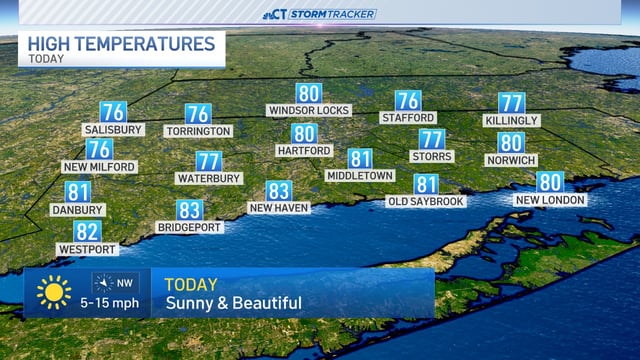
  • A cold front moving offshore early Monday ushered in cooler, drier air across New England, Northeast Ohio and Maryland.
  • Flash flood emergencies declared overnight in central Illinois and the St. Louis metro expired by Monday morning as rainfall rates slowed.
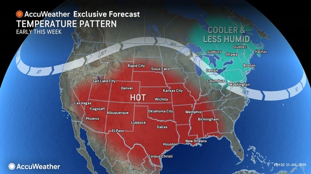
  • Meteorological models show a heat dome forming from a jet stream bulge converging with a large high-pressure system over the central and eastern US.
  • National Weather Service issued an extreme heat watch for Chicagoland beginning Wednesday with heat index values of 105 to 115°F possible; Kansas City is forecast to reach 100°F for the first time since August 2023.
  • British forecasters using GFS-based projections signal a likely heatwave around August 1 in southern and central England with temperatures near 31°C.