


Overview
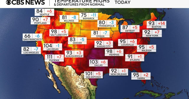
- A strong upper-level ridge over the central and eastern United States is driving a prolonged heat wave that pushed Tampa International Airport to a record 37.8 °C (100 °F) and sent Savannah’s heat index near 43 °C (110 °F).
- Extreme heat warnings remain in effect through Wednesday night from Georgia and northern Florida through New Orleans and St. Louis, with officials urging residents to limit outdoor activities and stay hydrated.
- The National Weather Service’s Storm Prediction Center has confirmed a derecho across the Upper Plains and Midwest, reporting straight-line gusts up to 99 mph and widespread damage to trees and power lines.
- Rain moving into the Southeast today is forecast to cool temperatures and alleviate stress on strained power grids following days of sustained highs.
- Meteorologists warn that these concurrent severe heat and storm events are part of a pattern of intensifying weather extremes linked to climate change, posing elevated risks for vulnerable communities.