

Overview
- Multiple rounds of rain and embedded thunderstorms are expected today from the Mid-Atlantic into New England, with the most numerous storms this afternoon and evening as the front moves through.
- The Storm Prediction Center places parts of the Mid-Atlantic in a Level 1 marginal risk, where isolated damaging wind gusts and a brief tornado cannot be ruled out.
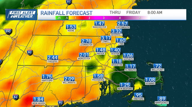
- Rainfall will be highly variable, with many areas near 0.5–1 inch but localized 2–3 inch downpours; training storms in central Louisiana have already prompted flash-flood warnings.
- Morning and evening travel could be slowed by downpours, gusty winds and ponding on roads, with several metro areas reporting wet commutes.
- Behind the front, drier and slightly cooler air arrives Friday into the weekend, as the National Hurricane Center tracks Tropical Storm Humberto and a nearby disturbance with uncertain tracks next week.