


Overview
- Showers and steady rain spread overnight into the Wednesday morning commute, then taper from west to east by midday with clearing in the afternoon.
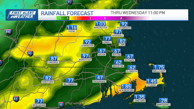
- Rainfall is generally forecast around 0.5 to 1.0 inch, with localized pockets of 1 to 3 inches where heavier bands train, raising the risk of ponding and slick travel.
- Temperatures drop from recent 70s–80s to highs in the 50s–60s, with overnight lows dipping into the 30s–40s and patchy frost possible Thursday and Friday, especially inland.
- The severe threat remains low, though a few non-severe thunderstorms and gusty winds are possible during the frontal passage.
- Forecasters are watching a possible coastal or tropical system late week with uncertain impacts, and Karnataka’s KSNDMC and IMD continue advisories for scattered to isolated heavy rain through Oct. 15.