

Overview
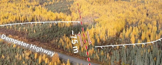
- Researchers used lidar, satellite and drone imagery to identify ancient fault scarps displaced by up to 1,000 m from a 2.6 Ma event and 75 m from a 132,000-year-old quake.
- A Geophysical Research Letters paper found the fault has accrued a six-metre slip deficit over the past 12,000 years at a strain rate of 0.2–0.8 mm per year, signaling a late-stage seismic cycle.
- Lead author Theron Finley warned that if accumulated strain is released, future earthquakes on the Tintina fault could exceed magnitude 7.5.
- On July 26, Canada’s National Seismic Hazard Model was updated to include the Tintina fault as a discrete seismic source, prompting a revision of regional hazard maps.
- Authorities in Yukon and Alaska are reviewing emergency response plans and assessing the resilience of highways, mines and communities near Dawson City.