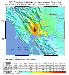
ShakeMap is a product of the U.S. Geological Survey to map the shaking of earthquakes. According to the USGS, "ShakeMaps provide near-real-time maps of ground motion and shaking intensity following significant earthquakes. From Wikipedia
Advancements in Earthquake Science and Early Warning Systems Highlight Progress, but Challenges Remain in Community Preparedness and Insurance Coverage